
Tormenta pasada
Ciclón postropical Douglas
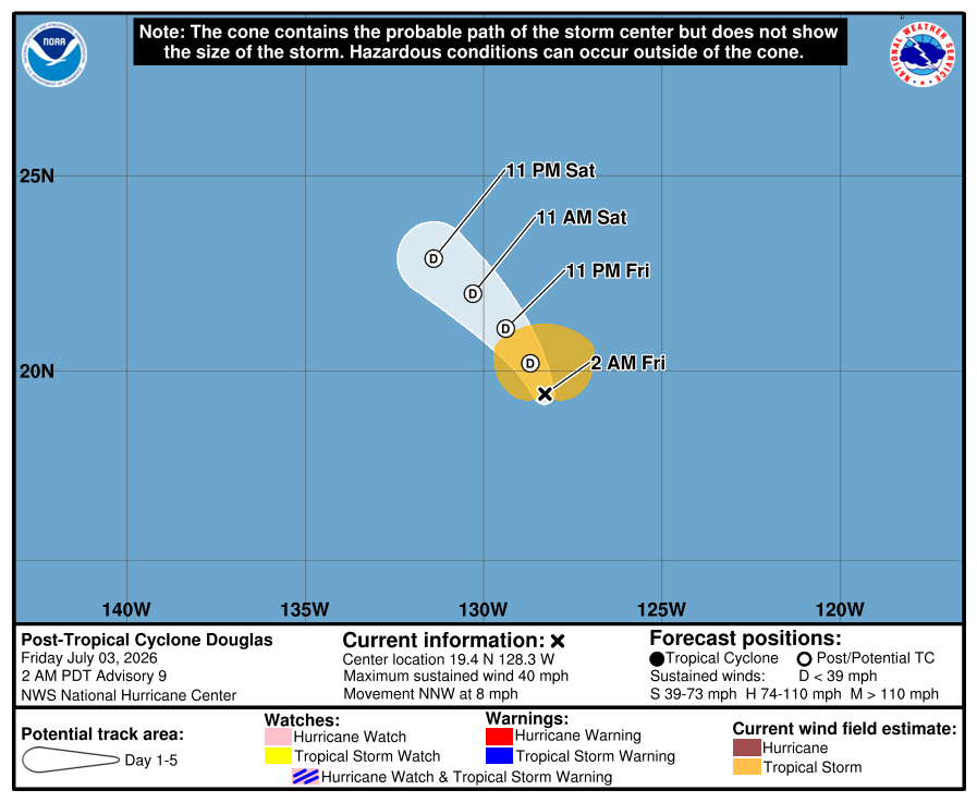
Aviso final del NHCEl NHC emitió su aviso final para Douglas. El gráfico oficial final, la trayectoria interactiva, la animación de viento basada en datos de NOAA y los avisos oficiales recientes se conservan a continuación.
Clasificación máxima alcanzada: Tormenta tropicaljul 1–3, 2026
Aviso de Douglas actualizado:
Datos clave
- Tipo
- Ciclón postropical
- Viento máximo sostenido
- 65 km/h
- Presión mínima
- 1003 mb
- Movimiento
- NNW 13 km/h
- Distancia a BCS
- 1646 km
- Tipo
- Ciclón postropical
- Viento máximo sostenido
- 65 km/h
- Presión mínima
- 1003 mb
- Movimiento
- NNW 13 km/h
- Distancia a BCS
- 1646 km
Trayectoria histórica
Fuentes del mapa: trayectoria y cono del NHCviento NOAA GFS. Visualización de BajaStorms.
Gráficos oficiales
Guía construida: No es el pronóstico oficial del NHC
Cronología de avisos
Cronología de avisos
DOUGLAS SE CONVIERTE EN UN CICLÓN POST-TROPICAL. ESTE ES EL ÚLTIMO AVISO DEL NHC. A las 2:00 AM PDT del viernes 03 de julio, el centro de Douglas se encontraba cerca de 19.4, -128.3 con desplazamiento hacia el NNO a 8 mph. La presión central mínima fue de 1003 mb con vientos máximos sostenidos de alrededor de 40 mph.
Traducción automática no oficial
...DOUGLAS SE CONVIERTE EN UN BAJO POST-TROPICAL... ...ESTE ES EL ÚLTIMO AVISO DEL NHC... A las 2:00 AM PDT del viernes 03 de julio, el centro de Douglas se encontraba cerca de 19.4, -128.3 con desplazamiento hacia el NNO a 8 mph. La presión central mínima fue de 1003 mb con vientos máximos sostenidos de alrededor de 40 mph.
Texto oficial del aviso del NHC
...DOUGLAS BECOMES A POST-TROPICAL LOW... ...THIS IS THE FINAL NHC ADVISORY... As of 2:00 AM PDT Fri Jul 03 the center of Douglas was located near 19.4, -128.3 with movement NNW at 8 mph. The minimum central pressure was 1003 mb with maximum sustained winds of about 40 mph.
Fuente: NOAA / NHC
Cronología de avisos #8
Douglas pronosticado para convertirse en un ciclón pos tropical el viernes.
Traducción automática no oficial
ZCZC MIATCPEP4 ALL
TTAA00 KNHC DDHHMM

BOLETÍN
Aviso del Ciclón Tropical Douglas Número   8
NWS National Hurricane Center Miami FL       EP042026
800 PM PDT Thu Jul 02 2026

...SE PRONOSTICA QUE DOUGLAS SE CONVIERTA EN UN CÍCLON POS TROPICAL EL VIERNES...


RESUMEN DE LAS 800 PM PDT...0300 UTC...INFORMACIÓN
----------------------------------------------
UBICACIÓN...18.8N 127.6W
A UNAS 1175 MI...1890 KM AL O DEL EXTREMO SUR DE BAJA CALIFORNIA
VIENTOS MÁXIMOS SOSTENIDOS...40 MPH...65 KM/H
MOVIMIENTO ACTUAL...NNO O 345 GRADOS A 7 MPH...11 KM/H
PRESIÓN CENTRAL MÍNIMA...1003 MB...29.62 PULGADAS


VIGILANCIAS Y AVISOS
--------------------
No hay vigilancias ni avisos costeros en efecto.


DISCUSIÓN Y PERSPECTIVA
----------------------
A las 800 PM PDT (0300 UTC), el centro de la Tormenta Tropical Douglas
se localizaba cerca de la latitud 18.8 Norte, longitud 127.6 Oeste. Douglas se
está moviendo hacia el norte-noroeste cerca de 7 mph (11 km/h), y se
espera que este movimiento continúe durante la noche. Se espera un movimiento hacia el
noroeste el viernes y el sábado.

Los vientos máximos sostenidos permanecen cerca de 40 mph (65 km/h), con rachas
más fuertes. Douglas debe comenzar a debilitarse durante la noche y se espera que
se convierta en un ciclón pos tropical el viernes.

Los vientos con fuerza de tormenta tropical se extienden hacia afuera hasta 90 millas (150 km)
desde el centro.

La presión central mínima estimada es de 1003 mb (29.62 pulgadas).


PELIGROS QUE AFECTAN TIERRA
----------------------
Ninguno.


PRÓXIMO AVISO
-------------
Próximo aviso completo a las 200 AM PDT.

$$
Pronosticador Blake

NNNN
Texto oficial del aviso del NHC
ZCZC MIATCPEP4 ALL
TTAA00 KNHC DDHHMM

BULLETIN
Tropical Storm Douglas Advisory Number   8
NWS National Hurricane Center Miami FL       EP042026
800 PM PDT Thu Jul 02 2026

...DOUGLAS FORECAST TO BECOME A REMNANT LOW ON FRIDAY...


SUMMARY OF 800 PM PDT...0300 UTC...INFORMATION
----------------------------------------------
LOCATION...18.8N 127.6W
ABOUT 1175 MI...1890 KM W OF THE SOUTHERN TIP OF BAJA CALIFORNIA
MAXIMUM SUSTAINED WINDS...40 MPH...65 KM/H
PRESENT MOVEMENT...NNW OR 345 DEGREES AT 7 MPH...11 KM/H
MINIMUM CENTRAL PRESSURE...1003 MB...29.62 INCHES


WATCHES AND WARNINGS
--------------------
There are no coastal watches or warnings in effect.


DISCUSSION AND OUTLOOK
----------------------
At 800 PM PDT (0300 UTC), the center of Tropical Storm Douglas was
located near latitude 18.8 North, longitude 127.6 West. Douglas is
moving toward the north-northwest near 7 mph (11 km/h), and this
motion is expected to continue overnight. A motion toward the
northwest is expected on Friday and Saturday.

Maximum sustained winds remain near 40 mph (65 km/h) with higher
gusts. Douglas should begin to weaken overnight and is expected to
become a post-tropical cyclone on Friday.

Tropical-storm-force winds extend outward up to 90 miles (150 km)
from the center.

The estimated minimum central pressure is 1003 mb (29.62 inches).


HAZARDS AFFECTING LAND
----------------------
None.


NEXT ADVISORY
-------------
Next complete advisory at 200 AM PDT.

$$
Forecaster Blake

NNNN
Fuente: NOAA / NHC
Cronología de avisos #7
Douglas ahora se mueve hacia el nor-noroeste sobre el Pacífico abierto. Se espera que se convierta en un sistema remanente el viernes.
Traducción automática no oficial
ZCZC MIATCPEP4 ALL
TTAA00 KNHC DDHHMM

BOLETÍN
Aviso del Tormenta Tropical Douglas Número   7
NWS National Hurricane Center Miami FL       EP042026
200 PM PDT Thu Jul 02 2026

...DOUGLAS AHORA SE DESPLAZA HACIA EL NOR-NOROESTE SOBRE EL PACÍFICO ABIERTO...
...SE ESPERA QUE SE CONVIERTA EN UNA BAJA REMANENTE EL VIERNES...


RESUMEN DE 200 PM PDT...2100 UTC...INFORMACIÓN
----------------------------------------------
UBICACIÓN...18.0N 127.4W
A UNAS 1180 MI...1900 KM AL OSO DE LA PUNTA SUR DE BAJA CALIFORNIA
VIENTOS MÁXIMOS SOSTENIDOS...40 MPH...65 KM/H
MOVIMIENTO ACTUAL...NNW O 345 GRADOS A 7 MPH...11 KM/H
PRESIÓN CENTRAL MÍNIMA...1003 MB...29.62 PULGADAS


VIGILANCIAS Y AVISOS
--------------------
No hay vigilancias ni avisos costeros en efecto.


DISCUSIÓN Y PERSPECTIVA
----------------------
A las 200 PM PDT (2100 UTC), el centro de la Tormenta Tropical Douglas
se localizaba cerca de la latitud 18.0 Norte, longitud 127.4 Oeste. Douglas
ahora se desplaza hacia el nor-noroeste cerca de 7 mph (11 km/h), y este
movimiento se espera que continúe esta noche. Se espera un movimiento hacia el
noroeste el viernes y el sábado.

Los vientos máximos sostenidos están cerca de 40 mph (65 km/h) con ráfagas
más fuertes. Se espera poco cambio en la intensidad durante las próximas
varias horas. Se pronostica una tendencia de debilitamiento a partir de
la noche de hoy, y se espera que Douglas se convierta en un ciclón postropical
el viernes.

Los vientos con fuerza de tormenta tropical se extienden hacia afuera hasta
90 millas (150 km) del centro.

La presión central mínima estimada es de 1003 mb (29.62 pulgadas).


PELIGROS QUE AFECTAN TIERRA
---------------------------
Ninguno.


PRÓXIMO AVISO
-------------
Próximo aviso completo a las 800 PM PDT.

$$
Pronosticador Beven

NNNN
Texto oficial del aviso del NHC
ZCZC MIATCPEP4 ALL
TTAA00 KNHC DDHHMM

BULLETIN
Tropical Storm Douglas Advisory Number   7
NWS National Hurricane Center Miami FL       EP042026
200 PM PDT Thu Jul 02 2026

...DOUGLAS NOW MOVING NORTH-NORTHWESTWARD OVER THE OPEN PACIFIC...
...EXPECTED TO BECOME A REMNANT LOW ON FRIDAY...


SUMMARY OF 200 PM PDT...2100 UTC...INFORMATION
----------------------------------------------
LOCATION...18.0N 127.4W
ABOUT 1180 MI...1900 KM WSW OF THE SOUTHERN TIP OF BAJA CALIFORNIA
MAXIMUM SUSTAINED WINDS...40 MPH...65 KM/H
PRESENT MOVEMENT...NNW OR 345 DEGREES AT 7 MPH...11 KM/H
MINIMUM CENTRAL PRESSURE...1003 MB...29.62 INCHES


WATCHES AND WARNINGS
--------------------
There are no coastal watches or warnings in effect.


DISCUSSION AND OUTLOOK
----------------------
At 200 PM PDT (2100 UTC), the center of Tropical Storm Douglas was
located near latitude 18.0 North, longitude 127.4 West. Douglas is
now moving toward the north-northwest near 7 mph (11 km/h), and this
motion is expected to continue tonight. A motion toward the
northwest is expected on Friday and Saturday.

Maximum sustained winds are near 40 mph (65 km/h) with higher gusts.
Little change in strength is expected for the next several hours. A
weakening trend is forecast beginning late tonight, and Douglas is
expected to become a post-tropical cyclone on Friday.

Tropical-storm-force winds extend outward up to 90 miles (150 km)
from the center.

The estimated minimum central pressure is 1003 mb (29.62 inches).


HAZARDS AFFECTING LAND
----------------------
None.


NEXT ADVISORY
-------------
Next complete advisory at 800 PM PDT.

$$
Forecaster Beven

NNNN
Fuente: NOAA / NHC
Cronología de avisos #6
Douglas se mueve hacia el norte hacia aguas más frías. Se espera que se convierta en una baja remanente el viernes.
Traducción automática no oficial
ZCZC MIATCPEP4 ALL
TTAA00 KNHC DDHHMM

BOLETÍN
Aviso de la Tormenta Tropical Douglas Número   6
NWS National Hurricane Center Miami FL       EP042026
800 AM PDT Jue Jul 02 2026

...DOUGLAS SE MUEVE HACIA EL NORTE HACIA AGUAS MÁS FRÍAS...
...SE ESPERA QUE SE CONVIERTA EN UNA BAJA REMANENTE EL VIERNES...


RESUMEN DE LAS 800 AM PDT...1500 UTC...INFORMACIÓN
----------------------------------------------
UBICACIÓN...17.4N 127.1W
A UNAS 1175 MI...1895 KM AL OSO DE LA PUNTA SUR DE BAJA CALIFORNIA
VIENTOS MÁXIMOS SOSTENIDOS...40 MPH...65 KM/H
MOVIMIENTO ACTUAL...N O 355 GRADOS A 6 MPH...9 KM/H
PRESIÓN CENTRAL MÍNIMA...1003 MB...29.62 PULGADAS


VIGILANCIAS Y AVISOS
--------------------
No hay vigilancias ni avisos costeros en efecto.


DISCUSIÓN Y PERSPECTIVA
----------------------
A las 800 AM PDT (1500 UTC), el centro de la Tormenta Tropical Douglas se
localizaba cerca de la latitud 17.4 Norte, longitud 127.1 Oeste. Douglas se
está moviendo hacia el norte cerca de 6 mph (9 km/h) y se espera que este
movimiento continúe hoy. Se pronostica un giro gradual hacia el noroeste
más tarde esta noche hasta el final de la semana.

Los vientos máximos sostenidos están cerca de 40 mph (65 km/h) con rachas más
fuertes. Se espera poco cambio en la intensidad hoy. Se pronostica una tendencia
de debilitamiento a partir de esta noche y hasta el viernes, y se espera que
Douglas se convierta en un ciclón postropical el viernes.

Los vientos de fuerza de tormenta tropical se extienden hacia afuera hasta 90 millas (150 km)
desde el centro.

La presión central mínima estimada es de 1003 mb (29.62 pulgadas).


PELIGROS QUE AFECTAN TIERRA
----------------------
Ninguno.


PRÓXIMO AVISO
-------------
Próximo aviso completo a las 200 PM PDT.

$$
Pronosticador Beven

NNNN
Texto oficial del aviso del NHC
ZCZC MIATCPEP4 ALL
TTAA00 KNHC DDHHMM

BULLETIN
Tropical Storm Douglas Advisory Number   6
NWS National Hurricane Center Miami FL       EP042026
800 AM PDT Thu Jul 02 2026

...DOUGLAS MOVING NORTHWARD TOWARD COOLER WATER...
...EXPECTED TO BECOME A REMNANT LOW ON FRIDAY...


SUMMARY OF 800 AM PDT...1500 UTC...INFORMATION
----------------------------------------------
LOCATION...17.4N 127.1W
ABOUT 1175 MI...1895 KM WSW OF THE SOUTHERN TIP OF BAJA CALIFORNIA
MAXIMUM SUSTAINED WINDS...40 MPH...65 KM/H
PRESENT MOVEMENT...N OR 355 DEGREES AT 6 MPH...9 KM/H
MINIMUM CENTRAL PRESSURE...1003 MB...29.62 INCHES


WATCHES AND WARNINGS
--------------------
There are no coastal watches or warnings in effect.


DISCUSSION AND OUTLOOK
----------------------
At 800 AM PDT (1500 UTC), the center of Tropical Storm Douglas was
located near latitude 17.4 North, longitude 127.1 West. Douglas is
moving toward the north near 6 mph (9 km/h)  and this motion is
expected to continue today. A gradual turn to the northwest is
forecast later tonight through the end of the week.

Maximum sustained winds are near 40 mph (65 km/h) with higher gusts.
Little change in strength is expected today. A weakening trend is
forecast beginning tonight into Friday, and Douglas is expected to
become a post-tropical cyclone on Friday.

Tropical-storm-force winds extend outward up to 90 miles (150 km)
from the center.

The estimated minimum central pressure is 1003 mb (29.62 inches).


HAZARDS AFFECTING LAND
----------------------
None.


NEXT ADVISORY
-------------
Next complete advisory at 200 PM PDT.

$$
Forecaster Beven

NNNN
Fuente: NOAA / NHC
Cronología de avisos #5
Douglas se mueve hacia el norte. Se espera que se convierta en un ciclón remanente el viernes.
Traducción automática no oficial
ZCZC MIATCPEP4 ALL
TTAA00 KNHC DDHHMM

BOLETÍN
Aviso del Tormenta Tropical Douglas Número   5
NWS National Hurricane Center Miami FL       EP042026
200 AM PDT Thu Jul 02 2026

...DOUGLAS MOVIÉNDOSE HACIA EL NORTE...
...SE ESPERA QUE SE CONVIERTA EN UN BAJO REMANENTE EL VIERNES...


RESUMEN DE LAS 200 AM PDT...0900 UTC...INFORMACIÓN
----------------------------------------------
UBICACIÓN...17.0N 127.1W
A UNAS 1185 MI...1910 KM AL OSO DE LA PUNTA SUR DE BAJA CALIFORNIA
VIENTOS MÁXIMOS SOSTENIDOS...40 MPH...65 KM/H
MOVIMIENTO ACTUAL...N O 350 GRADOS A 7 MPH...11 KM/H
PRESIÓN CENTRAL MÍNIMA...1003 MB...29.62 PULGADAS


VIGILANCIAS Y AVISOS
--------------------
No hay vigilancias ni avisos costeros en efecto.


DISCUSIÓN Y PERSPECTIVA
----------------------
A las 200 AM PDT (0900 UTC), el centro de la Tormenta Tropical Douglas
se localizaba cerca de la latitud 17.0 Norte, longitud 127.1 Oeste.
Douglas se está moviendo hacia el norte cerca de 7 mph (11 km/h) y se
espera que este movimiento continúe hoy. Se pronostica un giro gradual
hacia el noroeste más tarde esta noche hasta el final de la semana.

Los vientos máximos sostenidos están cerca de 40 mph (65 km/h) con
ráfagas más fuertes. Aunque es posible cierto ligero fortalecimiento en
las próximas varias horas, se pronostica una tendencia de debilitamiento
esta noche hasta el viernes. Se pronostica que Douglas se convierta en
un ciclón postropical el viernes.

Los vientos con fuerza de tormenta tropical se extienden hacia afuera
hasta 90 millas (150 km) desde el centro.

La presión central mínima estimada es de 1003 mb (29.62 pulgadas).


PELIGROS QUE AFECTAN A TIERRA
----------------------
Ninguno.


PRÓXIMO AVISO
-------------
Próximo aviso completo a las 800 AM PDT.

$$
Pronosticador Kelly

NNNN
Texto oficial del aviso del NHC
ZCZC MIATCPEP4 ALL
TTAA00 KNHC DDHHMM

BULLETIN
Tropical Storm Douglas Advisory Number   5
NWS National Hurricane Center Miami FL       EP042026
200 AM PDT Thu Jul 02 2026

...DOUGLAS MOVING NORTHWARD...
...EXPECTED TO BECOME A REMNANT LOW ON FRIDAY...


SUMMARY OF 200 AM PDT...0900 UTC...INFORMATION
----------------------------------------------
LOCATION...17.0N 127.1W
ABOUT 1185 MI...1910 KM WSW OF THE SOUTHERN TIP OF BAJA CALIFORNIA
MAXIMUM SUSTAINED WINDS...40 MPH...65 KM/H
PRESENT MOVEMENT...N OR 350 DEGREES AT 7 MPH...11 KM/H
MINIMUM CENTRAL PRESSURE...1003 MB...29.62 INCHES


WATCHES AND WARNINGS
--------------------
There are no coastal watches or warnings in effect.


DISCUSSION AND OUTLOOK
----------------------
At 200 AM PDT (0900 UTC), the center of Tropical Storm Douglas was
located near latitude 17.0 North, longitude 127.1 West. Douglas is
moving toward the north near 7 mph (11 km/h) and this motion is
expected to continue today. A gradual turn to the northwest is
forecast later tonight through the end of the week.

Maximum sustained winds are near 40 mph (65 km/h) with higher gusts.
Although some slight strengthening is possible the next several
hours, a weakening trend is forecast tonight into Friday. Douglas is
forecast to become a post-tropical cyclone on Friday.

Tropical-storm-force winds extend outward up to 90 miles (150 km)
from the center.

The estimated minimum central pressure is 1003 mb (29.62 inches).


HAZARDS AFFECTING LAND
----------------------
None.


NEXT ADVISORY
-------------
Next complete advisory at 800 AM PDT.

$$
Forecaster Kelly

NNNN
Fuente: NOAA / NHC