
Tormenta pasada
Ciclón postropical Elida
Aviso final del NHCEl NHC emitió su aviso final para Elida. El gráfico oficial final, la trayectoria interactiva, la animación de viento basada en datos de NOAA y los avisos oficiales recientes se conservan a continuación.
Clasificación máxima alcanzada: Tormenta tropicaljul 14–20, 2026
Aviso de Elida actualizado:
Datos clave
- Tipo
- Ciclón postropical
- Viento máximo sostenido
- 65 km/h
- Presión mínima
- 1000 mb
- Movimiento
- NNW 20 km/h
- Distancia a BCS
- 1227 km
- Tipo
- Ciclón postropical
- Viento máximo sostenido
- 65 km/h
- Presión mínima
- 1000 mb
- Movimiento
- NNW 20 km/h
- Distancia a BCS
- 1227 km
Trayectoria histórica
Fuentes del mapa: trayectoria y cono del NHCviento NOAA GFS. Visualización de BajaStorms.
Gráficos oficiales
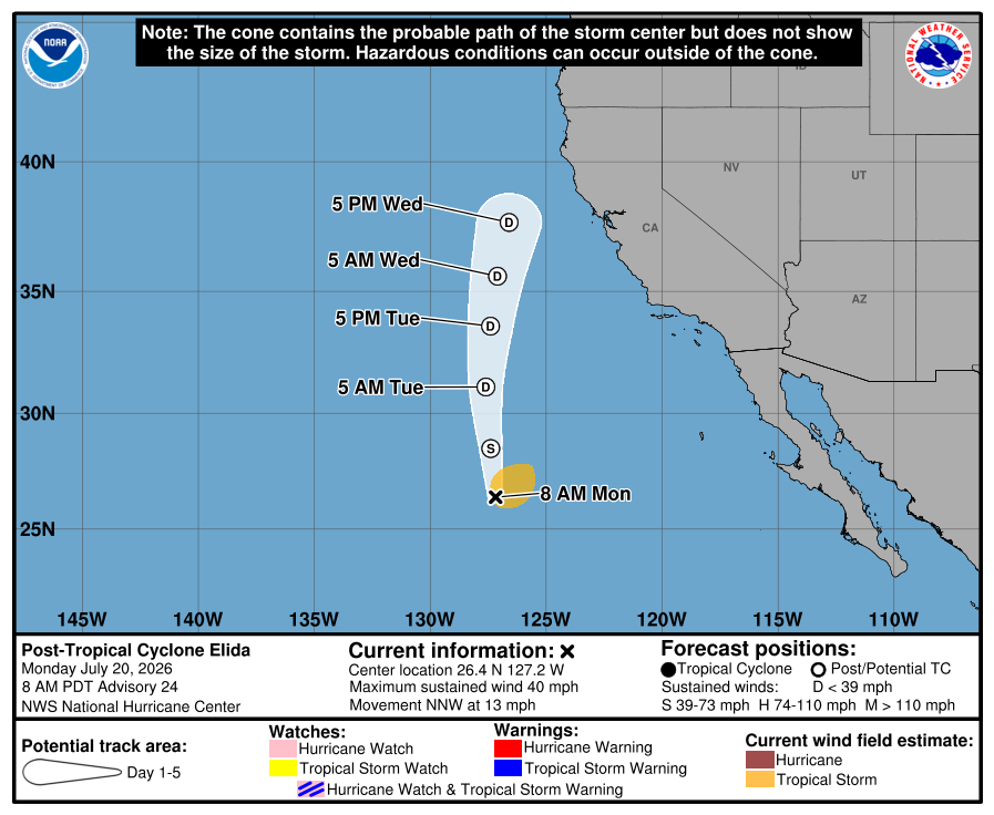
Guía construida: No es el pronóstico oficial del NHC
Cronología de avisos
Cronología de avisos
ELIDA BECOMES POST-TROPICAL. DANGEROUS SURF AND HIGH RISK OF RIP CURRENTS IN SOUTHERN CALIFORNIA CONTINUES. As of 8:00 AM PDT Mon Jul 20 the center of Elida was located near 26.4, -127.2 with movement NNW at 13 mph. The minimum central pressure was 1000 mb with maximum sustained winds of about 40 mph.
Texto oficial del aviso del NHC
...ELIDA BECOMES POST-TROPICAL... ...DANGEROUS SURF AND HIGH RISK OF RIP CURRENTS IN SOUTHERN CALIFORNIA CONTINUES... As of 8:00 AM PDT Mon Jul 20 the center of Elida was located near 26.4, -127.2 with movement NNW at 13 mph. The minimum central pressure was 1000 mb with maximum sustained winds of about 40 mph.
Fuente: NOAA / NHC
Cronología de avisos #23
Elida perdiendo convección profunda.
Traducción automática no oficial
ZCZC MIATCPEP5 ALL
TTAA00 KNHC DDHHMM

BOLETÍN
Aviso del ciclón tropical Elida Número  23
NWS National Hurricane Center Miami FL       EP052026
200 AM PDT Mon Jul 20 2026

...ELIDA PERDIENDO CONVECCIÓN PROFUNDA...
...OLEAJE PELIGROSO Y ALTO RIESGO DE CORRIENTES DE RETORNO EN EL SUR DE
CALIFORNIA...


RESUMEN DE LA INFORMACIÓN DE LAS 200 AM PDT...0900 UTC
----------------------------------------------
UBICACIÓN...25.3N 127.1W
A UNAS 1095 MI...1765 KM AL ONO DEL EXTREMO SUR DE BAJA CALIFORNIA
VIENTOS MÁXIMOS SOSTENIDOS...50 MPH...85 KM/H
MOVIMIENTO ACTUAL...NNO O 340 GRADOS A 13 MPH...20 KM/H
PRESIÓN CENTRAL MÍNIMA...996 MB...29.42 PULGADAS


VIGILANCIAS Y AVISOS
--------------------
No hay vigilancias o avisos costeros en efecto.


DISCUSIÓN Y PERSPECTIVAS
----------------------
A las 200 AM PDT (0900 UTC), el centro de la Tormenta Tropical Elida se
ubicaba cerca de la latitud 25.3 Norte, longitud 127.1 Oeste. Elida se
está moviendo hacia el nor-noroeste cerca de 13 mph (20 km/h). Se pronostica un giro hacia
el norte con un aumento en la velocidad de avance durante
los próximos dos días.

Los vientos máximos sostenidos son de cerca de 50 mph (85 km/h), con ráfagas más fuertes.
Se anticipa un debilitamiento gradual. Se pronostica que Elida se
convertirá en un ciclón postropical hoy o esta noche.

Los vientos con fuerza de tormenta tropical se extienden hacia afuera hasta 160 millas (260 km)
desde el centro.

La presión central mínima estimada es de 996 mb (29.42 pulgadas).


PELIGROS QUE AFECTAN TIERRA
----------------------
OLEAJE:  Los marejadas generadas por Elida afectarán porciones de la costa oeste
de la Península de Baja California y el sur de California
durante los próximos varios días. Estas marejadas probablemente darán lugar a
condiciones de oleaje y corrientes de retorno que amenazan la vida. Consulte
los productos de su oficina meteorológica local.


PRÓXIMO AVISO
-------------
Próximo aviso completo a las 800 AM PDT.

$$
Pronosticador Kelly

NNNN
Texto oficial del aviso del NHC
ZCZC MIATCPEP5 ALL
TTAA00 KNHC DDHHMM

BULLETIN
Tropical Storm Elida Advisory Number  23
NWS National Hurricane Center Miami FL       EP052026
200 AM PDT Mon Jul 20 2026

...ELIDA LOSING DEEP CONVECTION...
...DANGEROUS SURF AND HIGH RISK OF RIP CURRENTS IN SOUTHERN
CALIFORNIA...


SUMMARY OF 200 AM PDT...0900 UTC...INFORMATION
----------------------------------------------
LOCATION...25.3N 127.1W
ABOUT 1095 MI...1765 KM WNW OF THE SOUTHERN TIP OF BAJA CALIFORNIA
MAXIMUM SUSTAINED WINDS...50 MPH...85 KM/H
PRESENT MOVEMENT...NNW OR 340 DEGREES AT 13 MPH...20 KM/H
MINIMUM CENTRAL PRESSURE...996 MB...29.42 INCHES


WATCHES AND WARNINGS
--------------------
There are no coastal watches or warnings in effect.


DISCUSSION AND OUTLOOK
----------------------
At 200 AM PDT (0900 UTC), the center of Tropical Storm Elida was
located near latitude 25.3 North, longitude 127.1 West. Elida is
moving toward the north-northwest near 13 mph (20 km/h). A turn to
the north with an increase in forward speed is forecast the
during the next couple days.

Maximum sustained winds are near 50 mph (85 km/h) with higher gusts.
Gradual weakening is anticipated. Elida is forecast to become a
post-tropical cyclone today or tonight.

Tropical-storm-force winds extend outward up to 160 miles (260 km)
from the center.

The estimated minimum central pressure is 996 mb (29.42 inches).


HAZARDS AFFECTING LAND
----------------------
SURF:  Swells generated by Elida will affect portions of the west
coast of the Baja California Peninsula and southern California
during the next several days. These swells will likely result in
life-threatening surf and rip current conditions. Please consult
products from your local weather office.


NEXT ADVISORY
-------------
Next complete advisory at 800 AM PDT.

$$
Forecaster Kelly

NNNN
Fuente: NOAA / NHC
Cronología de avisos #22
Elida comienza a acelerarse hacia aguas más frías.
Traducción automática no oficial
ZCZC MIATCPEP5 ALL
TTAA00 KNHC DDHHMM

BULLETIN
Aviso de la Tormenta Tropical Elida Número  22
NWS National Hurricane Center Miami FL       EP052026
800 PM PDT Sun Jul 19 2026

...ELIDA COMIENZA A ACELERARSE HACIA AGUAS MÁS FRÍAS...


RESUMEN DE LAS 800 PM PDT...0300 UTC...INFORMACIÓN
----------------------------------------------
UBICACIÓN...24.1N 126.8W
A UNAS 1075 MI...1725 KM O DEL EXTREMO SUR DE BAJA CALIFORNIA
VIENTOS MÁXIMOS SOSTENIDOS...50 MPH...85 KM/H
MOVIMIENTO ACTUAL...NNW O 335 GRADOS A 12 MPH...19 KM/H
PRESIÓN CENTRAL MÍNIMA...996 MB...29.42 PULGADAS


VIGILANCIAS Y AVISOS
--------------------
No hay vigilancias ni avisos costeros en efecto.


DISCUSIÓN Y PERSPECTIVA
----------------------
A las 800 PM PDT (0300 UTC), el centro de la Tormenta Tropical Elida estaba
ubicado cerca de la latitud 24.1 Norte, longitud 126.8 Oeste. Elida se
está moviendo hacia el norte-noroeste cerca de 12 mph (19 km/h). Se espera
un giro hacia el norte a una velocidad ligeramente mayor esta noche
y hasta el lunes. Entonces se espera que el sistema continúe hacia el norte
pero que gradualmente se desacelere durante el día o dos siguientes.

Los vientos máximos sostenidos están cerca de 50 mph (85 km/h) con rachas más altas.
Se anticipa un debilitamiento gradual. Se pronostica que Elida se convierta en un
remanente de baja presión tarde el lunes o temprano el martes.

Los vientos con fuerza de tormenta tropical se extienden hacia afuera hasta 175 millas (280 km)
desde el centro.

La presión central mínima estimada es de 996 mb (29.42 pulgadas).


PELIGROS QUE AFECTAN A TIERRA
----------------------
OLEAJE:  El oleaje generado por Elida afectará porciones de la costa oeste de la
Península de Baja California y el sur de California
durante los próximos varios días. Es probable que este oleaje resulte en
condiciones de resaca y corrientes de retorno potencialmente mortales. Consulte
los productos de su oficina meteorológica local.


PRÓXIMO AVISO
-------------
Próximo aviso completo a las 200 AM PDT.

$$
Pronosticador D. Zelinsky

NNNN
Texto oficial del aviso del NHC
ZCZC MIATCPEP5 ALL
TTAA00 KNHC DDHHMM

BULLETIN
Tropical Storm Elida Advisory Number  22
NWS National Hurricane Center Miami FL       EP052026
800 PM PDT Sun Jul 19 2026

...ELIDA BEGINS TO ACCELERATE TOWARD COLDER WATERS...


SUMMARY OF 800 PM PDT...0300 UTC...INFORMATION
----------------------------------------------
LOCATION...24.1N 126.8W
ABOUT 1075 MI...1725 KM W OF THE SOUTHERN TIP OF BAJA CALIFORNIA
MAXIMUM SUSTAINED WINDS...50 MPH...85 KM/H
PRESENT MOVEMENT...NNW OR 335 DEGREES AT 12 MPH...19 KM/H
MINIMUM CENTRAL PRESSURE...996 MB...29.42 INCHES


WATCHES AND WARNINGS
--------------------
There are no coastal watches or warnings in effect.


DISCUSSION AND OUTLOOK
----------------------
At 800 PM PDT (0300 UTC), the center of Tropical Storm Elida was
located near latitude 24.1 North, longitude 126.8 West. Elida is
moving toward the north-northwest near 12 mph (19 km/h). A turn
toward the north at a slightly faster speed is expected tonight
through Monday. The system is then expected to continue northward
but gradually slow down over the following day or two.

Maximum sustained winds are near 50 mph (85 km/h) with higher gusts.
Gradual weakening is anticipated. Elida is forecast to become a
remnant low late Monday or early Tuesday.

Tropical-storm-force winds extend outward up to 175 miles (280 km)
from the center.

The estimated minimum central pressure is 996 mb (29.42 inches).


HAZARDS AFFECTING LAND
----------------------
SURF:  Swells generated by Elida will affect portions of the west
coast of the Baja California Peninsula and southern California
during the next several days. These swells will likely result in
life-threatening surf and rip current conditions. Please consult
products from your local weather office.


NEXT ADVISORY
-------------
Next complete advisory at 200 AM PDT.

$$
Forecaster D. Zelinsky

NNNN
Fuente: NOAA / NHC
Cronología de avisos #21
Boletín del Tormenta Tropical Elida Número 21
Traducción automática no oficial
ZCZC MIATCPEP5 ALL
TTAA00 KNHC DDHHMM

BOLETÍN
Boletín de la Tormenta Tropical Elida Número  21
NWS Centro Nacional de Huracanes de Miami FL       EP052026
200 PM PDT dom 19 jul 2026

...SE ESPERA QUE ELIDA SE DÉBILITE A UNA DEPRESIÓN REMANENTE DENTRO DE UN PAR DE DÍAS...


RESUMEN DE LAS 200 PM PDT...2100 UTC...INFORMACIÓN
----------------------------------------------
UBICACIÓN...23.2N 125.9W
A UNAS 1015 MI...1635 KM AL O DE LA PUNTA SUR DE BAJA CALIFORNIA
VIENTOS MÁXIMOS SOSTENIDOS...60 MPH...95 KM/H
MOVIMIENTO ACTUAL...NNO O 340 GRADOS A 10 MPH...17 KM/H
PRESIÓN CENTRAL MÍNIMA...996 MB...29.42 PULGADAS


VIGILANCIAS Y AVISOS
--------------------
No hay vigilancias ni avisos costeros en efecto.


DISCUSIÓN Y PERSPECTIVA
----------------------
A las 200 PM PDT (2100 UTC), el centro de la Tormenta Tropical Elida
se localizaba cerca de la latitud 23.2 Norte, longitud 125.9 Oeste. Elida
se está moviendo hacia el nor-noroeste cerca de 10 mph (17 km/h). Se
espera que la tormenta aumente su velocidad de avance a medida que
se desplace más hacia el norte durante los próximos un par de días.

Los vientos máximos sostenidos son de cerca de 60 mph (95 km/h) con
ráfagas más fuertes. Se espera debilitamiento durante los próximos un par
de días, y es probable que el ciclón se disipe a finales del miércoles.

Los vientos de fuerza de tormenta tropical se extienden hacia afuera
hasta 185 millas (295 km) desde el centro.

La presión central mínima estimada es de 996 mb (29.42 pulgadas).


PELIGROS QUE AFECTAN TIERRA
----------------------
OLEAJE:  El mar de fondo generado por Elida afectará porciones de la
costa oeste de la Península de Baja California y el sur de California
durante hasta principios de la próxima semana. Este oleaje probablemente
provocará condiciones de resaca y corrientes de resaca que ponen en riesgo
la vida. Consulte los productos de su oficina meteorológica local.


PRÓXIMO AVISO
-------------
Próximo aviso completo a las 800 PM PDT.

$$
Pronosticadores Katz/Pasch

NNNN
Texto oficial del aviso del NHC
ZCZC MIATCPEP5 ALL
TTAA00 KNHC DDHHMM

BULLETIN
Tropical Storm Elida Advisory Number  21
NWS National Hurricane Center Miami FL       EP052026
200 PM PDT Sun Jul 19 2026

...ELIDA EXPECTED TO WEAKEN TO A REMNANT LOW WITHIN A COUPLE OF
DAYS...


SUMMARY OF 200 PM PDT...2100 UTC...INFORMATION
----------------------------------------------
LOCATION...23.2N 125.9W
ABOUT 1015 MI...1635 KM W OF THE SOUTHERN TIP OF BAJA CALIFORNIA
MAXIMUM SUSTAINED WINDS...60 MPH...95 KM/H
PRESENT MOVEMENT...NNW OR 340 DEGREES AT 10 MPH...17 KM/H
MINIMUM CENTRAL PRESSURE...996 MB...29.42 INCHES


WATCHES AND WARNINGS
--------------------
There are no coastal watches or warnings in effect.


DISCUSSION AND OUTLOOK
----------------------
At 200 PM PDT (2100 UTC), the center of Tropical Storm Elida was
located near latitude 23.2 North, longitude 125.9 West. Elida is
moving toward the north-northwest near 10 mph (17 km/h). The storm
is expected to increase in forward speed as it turns more northward
over the next couple of days.

Maximum sustained winds are near 60 mph (95 km/h) with higher gusts.
Weakening is expected during the next couple of days, and the
cyclone is likely to dissipate by late Wednesday.

Tropical-storm-force winds extend outward up to 185 miles (295 km)
from the center.

The estimated minimum central pressure is 996 mb (29.42 inches).


HAZARDS AFFECTING LAND
----------------------
SURF:  Swells generated by Elida will affect portions of the west
coast of the Baja California Peninsula and southern California
through early next week. These swells will likely result in
life-threatening surf and rip current conditions. Please consult
products from your local weather office.


NEXT ADVISORY
-------------
Next complete advisory at 800 PM PDT.

$$
Forecaster Katz/Pasch

NNNN
Fuente: NOAA / NHC
Cronología de avisos #20
Elida probablemente se debilitará a un mínimo remanente en un par de días.
Traducción automática no oficial
ZCZC MIATCPEP5 ALL
TTAA00 KNHC DDHHMM

BOLETÍN
Aviso del Ciclón Tropical Elida Número 20
NWS National Hurricane Center Miami FL       EP052026
800 AM PDT Sun Jul 19 2026

...ELIDA PROBABLEMENTE SE DEBILITARÁ A UN MÍNIMO REMANENTE EN UN PAR DE DÍAS...


RESUMEN DE LA INFORMACIÓN DE LAS 800 AM PDT...1500 UTC
----------------------------------------------
UBICACIÓN...22.2N 125.3W
APROXIMADAMENTE 985 MI...1580 KM O DEL EXTREMO SUR DE BAJA CALIFORNIA
VIENTOS MÁXIMOS SOSTENIDOS...60 MPH...95 KM/H
MOVIMIENTO ACTUAL...NNO O 340 GRADOS A 9 MPH...15 KM/H
PRESIÓN CENTRAL MÍNIMA...996 MB...29.42 PULGADAS


VIGILANCIAS Y AVISOS
--------------------
No hay vigilancias ni avisos costeros en efecto.


DISCUSIÓN Y PERSPECTIVAS
----------------------
A las 800 AM PDT (1500 UTC), el centro de la Tormenta Tropical Elida
se localizaba cerca de la latitud 22.2 Norte, longitud 125.3 Oeste. Elida
se está moviendo hacia el norte-noroeste a cerca de 9 mph (15 km/h). Se
espera que la tormenta aumente su velocidad de traslación a medida que
se gire más hacia el norte durante los próximos un par de días.

Los vientos máximos sostenidos están cerca de 60 mph (95 km/h), con
rachas más fuertes. Se espera un debilitamiento constante durante los
próximos un par de días, y es probable que el ciclón se disipe hacia el
final del miércoles.

Los vientos con fuerza de tormenta tropical se extienden hacia afuera
hasta 185 millas (295 km) desde el centro.

La presión central mínima estimada es 996 mb (29.42 pulgadas).


PELIGROS QUE AFECTAN TIERRA
----------------------
OLEAJE: Los marejadas generadas por Elida afectarán partes de la costa
oeste de la Península de Baja California y del sur de California hasta
principios de la próxima semana. Estas marejadas probablemente darán
lugar a condiciones de oleaje y corrientes de resaca potencialmente
mortales. Consulte los productos de su oficina meteorológica local.


PRÓXIMO AVISO
-------------
Próximo aviso completo a las 200 PM PDT.

$$
Pronosticadores Katz/Pasch

NNNN
Texto oficial del aviso del NHC
ZCZC MIATCPEP5 ALL
TTAA00 KNHC DDHHMM

BULLETIN
Tropical Storm Elida Advisory Number  20
NWS National Hurricane Center Miami FL       EP052026
800 AM PDT Sun Jul 19 2026

...ELIDA LIKELY TO WEAKEN TO A REMNANT LOW IN A COUPLE OF DAYS...


SUMMARY OF 800 AM PDT...1500 UTC...INFORMATION
----------------------------------------------
LOCATION...22.2N 125.3W
ABOUT 985 MI...1580 KM W OF THE SOUTHERN TIP OF BAJA CALIFORNIA
MAXIMUM SUSTAINED WINDS...60 MPH...95 KM/H
PRESENT MOVEMENT...NNW OR 340 DEGREES AT 9 MPH...15 KM/H
MINIMUM CENTRAL PRESSURE...996 MB...29.42 INCHES


WATCHES AND WARNINGS
--------------------
There are no coastal watches or warnings in effect.


DISCUSSION AND OUTLOOK
----------------------
At 800 AM PDT (1500 UTC), the center of Tropical Storm Elida was
located near latitude 22.2 North, longitude 125.3 West. Elida is
moving toward the north-northwest near 9 mph (15 km/h). The storm
is expected to increase in forward speed as it turns further
northward over the next couple of days.

Maximum sustained winds are near 60 mph (95 km/h) with higher gusts.
Steady weakening is expected during the next couple of days, and
the cyclone is likely to dissipate by late Wednesday.

Tropical-storm-force winds extend outward up to 185 miles (295 km)
from the center.

The estimated minimum central pressure is 996 mb (29.42 inches).


HAZARDS AFFECTING LAND
----------------------
SURF:  Swells generated by Elida will affect portions of the west
coast of the Baja California Peninsula and southern California
through early next week. These swells will likely result in
life-threatening surf and rip current conditions. Please consult
products from your local weather office.


NEXT ADVISORY
-------------
Next complete advisory at 200 PM PDT.

$$
Forecaster Katz/Pasch

NNNN
Fuente: NOAA / NHC