
Tormenta pasada
Ciclón postropical Fausto
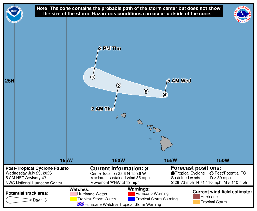
Aviso final del NHCEl NHC emitió su aviso final para Fausto. El gráfico oficial final, la trayectoria interactiva, la animación de viento basada en datos de NOAA y los avisos oficiales recientes se conservan a continuación.
Clasificación máxima alcanzada: huracán categoría 2jul 19–29, 2026
Aviso de Fausto actualizado:
Datos clave
- Tipo
- Ciclón postropical
- Viento máximo sostenido
- 55 km/h
- Presión mínima
- 1008 mb
- Movimiento
- WNW 20 km/h
- Distancia a BCS
- 4082 km
- Tipo
- Ciclón postropical
- Viento máximo sostenido
- 55 km/h
- Presión mínima
- 1008 mb
- Movimiento
- WNW 20 km/h
- Distancia a BCS
- 4082 km
Trayectoria histórica
Fuentes del mapa: trayectoria y cono del NHCviento NOAA GFS. Visualización de BajaStorms.
Gráficos oficiales
Guía construida: No es el pronóstico oficial del NHC
Cronología de avisos
Cronología de avisos
FAUSTO DEGENERATES TO A REMNANT LOW PRESSURE AREA. SIGNIFICANT SURF STILL EXPECTED FOR THE HAWAIIAN ISLANDS THROUGH TODAY. As of 5:00 AM HST Wed Jul 29 the center of Fausto was located near 23.8, -155.6 with movement WNW at 13 mph. The minimum central pressure was 1008 mb with maximum sustained winds of about 35 mph.
Texto oficial del aviso del NHC
...FAUSTO DEGENERATES TO A REMNANT LOW PRESSURE AREA... ...SIGNIFICANT SURF STILL EXPECTED FOR THE HAWAIIAN ISLANDS THROUGH TODAY... As of 5:00 AM HST Wed Jul 29 the center of Fausto was located near 23.8, -155.6 with movement WNW at 13 mph. The minimum central pressure was 1008 mb with maximum sustained winds of about 35 mph.
Fuente: NOAA / CPHC
Cronología de avisos #42
Boletín de la Depresión Tropical Fausto Número 42
Traducción automática no oficial
ZCZC HFOTCPCP1 ALL
TTAA00 PHFO DDHHMM

BOLETÍN
Boletín de la Depresión Tropical Fausto Número  42
NWS Central Pacific Hurricane Center Honolulu HI   EP062026
Emitido por NWS National Hurricane Center Miami FL
1100 PM HST mar Jul 28 2026

...FAUSTO AHORA ES UNA DEPRESIÓN TROPICAL PERO SE ESPERA AUN OLAS SIGNIFICATIVAS
PARA LAS ISLAS HAWAIIANAS HASTA EL MIÉRCOLES...


RESUMEN DE LAS 1100 PM HST...0900 UTC...INFORMACIÓN
-----------------------------------------------
UBICACIÓN...23.3N 154.5W
UNOS 250 MI...405 KM AL N DE HILO HAWAII
UNOS 255 MI...415 KM AL ENE DE HONOLULU HAWAII
VIENTOS SOSTENIDOS MÁXIMOS...35 MPH...55 KM/H
MOVIMIENTO ACTUAL...WNW O 290 GRADOS A 12 MPH...19 KM/H
PRESIÓN CENTRAL MÍNIMA...1008 MB...29.77 PULGADAS


VIGILANCIAS Y AVISOS
--------------------
No hay vigilancias ni avisos costeros en efecto.

Los intereses en las Islas Hawaianas deben monitorear el
progreso de Fausto.


DISCUSIÓN Y PERSPECTIVA
----------------------
A las 1100 PM HST (0900 UTC), el centro de la Depresión Tropical Fausto
estaba localizado cerca de la latitud 23.3 Norte, longitud 154.5 Oeste. La
depresión se está moviendo hacia el oeste-noroeste cerca de 12 mph (19 km/h)
y se espera que este movimiento continúe durante los próximos un par de días.
En la trayectoria pronosticada, Fausto pasará al norte de las
Islas Hawaianas hasta finales del miércoles.

Los vientos máximos sostenidos han disminuido a cerca de 35 mph (55 km/h) con
ráfagas más fuertes. Es probable que continúe debilitándose, y se espera que Fausto
se convierta en un sistema remanente de baja presión post-tropical el miércoles.

La presión central mínima estimada es de 1008 mb (29.77 pulgadas).


PELIGROS QUE AFECTAN TIERRA
----------------------
Los mensajes clave para Fausto se pueden encontrar en la Discusión
sobre Ciclones Tropicales bajo el encabezado AWIPS HFOTCDCP1 y el encabezado WMO WTPA41 PHFO.

OLEAJE: El oleaje generado por Fausto se está extendiendo hacia el oeste a través de las
Islas Hawaianas a lo largo de las costas expuestas orientadas al este y continuará siendo peligroso el miércoles mientras Fausto pasa al norte de las islas.  El
olaje grande y las corrientes fuertes provocarán condiciones peligrosas
 a lo largo de las costas expuestas.  Consulte los productos de su
oficina meteorológica local.


PRÓXIMO AVISO
-------------
Próximo aviso completo a las 500 AM HST.

$$
Pronosticador Hagen

NNNN
Texto oficial del aviso del NHC
ZCZC HFOTCPCP1 ALL
TTAA00 PHFO DDHHMM

BULLETIN
Tropical Depression Fausto Advisory Number  42
NWS Central Pacific Hurricane Center Honolulu HI   EP062026
Issued by NWS National Hurricane Center Miami FL
1100 PM HST Tue Jul 28 2026

...FAUSTO NOW A TROPICAL DEPRESSION BUT SIGNIFICANT SURF STILL
EXPECTED FOR THE HAWAIIAN ISLANDS THROUGH WEDNESDAY...


SUMMARY OF 1100 PM HST...0900 UTC...INFORMATION
-----------------------------------------------
LOCATION...23.3N 154.5W
ABOUT 250 MI...405 KM N OF HILO HAWAII
ABOUT 255 MI...415 KM ENE OF HONOLULU HAWAII
MAXIMUM SUSTAINED WINDS...35 MPH...55 KM/H
PRESENT MOVEMENT...WNW OR 290 DEGREES AT 12 MPH...19 KM/H
MINIMUM CENTRAL PRESSURE...1008 MB...29.77 INCHES


WATCHES AND WARNINGS
--------------------
There are no coastal watches or warnings in effect.

Interests in the Hawaiian Islands should monitor the progress of
Fausto.


DISCUSSION AND OUTLOOK
----------------------
At 1100 PM HST (0900 UTC), the center of Tropical Depression Fausto
was located near latitude 23.3 North, longitude 154.5 West. The
depression is moving toward the west-northwest near 12 mph (19 km/h)
and this motion is expected to continue for the next couple of days.
On the forecast track, Fausto will pass north of the Hawaiian
Islands through late Wednesday.

Maximum sustained winds have decreased to near 35 mph (55 km/h) with
higher gusts. Additional weakening is likely, and Fausto is expected
to become a post-tropical remnant low on Wednesday.

The estimated minimum central pressure is 1008 mb (29.77 inches).


HAZARDS AFFECTING LAND
----------------------
Key messages for Fausto can be found in the Tropical Cyclone
Discussion under AWIPS header HFOTCDCP1 and WMO header WTPA41 PHFO.

SURF: Surf generated by Fausto is building westward across the
Hawaiian Islands along exposed east-facing shores and will
remain dangerous on Wednesday as Fausto passes north of the
islands.  Large surf and strong currents will lead to dangerous
conditions along exposed shores.  Please consult products from your
local weather office.


NEXT ADVISORY
-------------
Next complete advisory at 500 AM HST.

$$
Forecaster Hagen

NNNN
Fuente: NOAA / NHC
Cronología de avisos #41
Boletín del ciclón tropical Fausto Número 41
Traducción automática no oficial
ZCZC HFOTCPCP1 ALL
TTAA00 PHFO DDHHMM

BULLETIN
Boletín del ciclón tropical Fausto Número  41
NWS Central Pacific Hurricane Center Honolulu HI   EP062026
Emitido por NWS National Hurricane Center Miami FL
500 PM HST Tue Jul 28 2026

...FAUSTO CONTINÚA DEBILITÁNDOSE GRADUALMENTE, PERO AÚN SE ESPERA
OLEAJE SIGNIFICATIVO PARA LAS ISLAS HAWAIANAS DURANTE LOS PRÓXIMOS
DÍAS...


RESUMEN DE LA INFORMACIÓN DE LAS 500 PM HST...0300 UTC
----------------------------------------------
UBICACIÓN...23.0N 153.4W
A UNAS 255 MI...405 KM NNE DE HILO HAWAII
A UNAS 310 MI...500 KM ENE DE HONOLULU HAWAII
VIENTOS MÁXIMOS SOSTENIDOS...40 MPH...65 KM/H
MOVIMIENTO ACTUAL...WNW O 285 GRADOS A 12 MPH...19 KM/H
PRESIÓN CENTRAL MÍNIMA...1006 MB...29.71 INCHES


VIGILANCIAS Y AVISOS
--------------------
No hay vigilancias ni avisos costeros en efecto.

Los intereses en las Islas Hawaianas deben monitorear el progreso de
Fausto.


DISCUSIÓN Y PERSPECTIVA
----------------------
A las 500 PM HST (0300 UTC), el centro de la Tormenta Tropical Fausto se
ubicaba cerca de la latitud 23.0 Norte, longitud 153.4 Oeste.  Fausto se
mueve hacia el oeste-noroeste cerca de 12 mph (19 km/h), y se espera que
un movimiento generalmente hacia el oeste-noroeste continúe durante los
próximos días.  En la trayectoria pronosticada, Fausto debe pasar al norte de
las Islas Hawaianas esta noche hasta entrada la noche del miércoles.

Los vientos máximos sostenidos han disminuido a cerca de 40 mph (65 km/h)
con ráfagas más fuertes.  Es probable que ocurra un debilitamiento adicional, y se
espera que Fausto se convierta en una depresión tropical a primeras horas del miércoles, y
en un mínimo remanente para entrada la noche del miércoles.

Los vientos con fuerza de tormenta tropical se extienden hacia afuera hasta 160 millas (260 km)
al noreste del centro.

La presión central mínima estimada es de 1006 mb (29.71 inches).


PELIGROS QUE AFECTAN TIERRA
----------------------
Los mensajes clave para Fausto pueden encontrarse en la Discusión del Ciclón Tropical
bajo el encabezado AWIPS HFOTCDCP1 y el encabezado WMO WTPA41 PHFO.

OLEAJE: El oleaje generado por Fausto continuará aumentando hacia el oeste
a través de las Islas Hawaianas a lo largo de las costas expuestas con orientación al este
a lo largo de esta noche conforme Fausto se aproxima y comienza a pasar al norte de las
islas.  El oleaje grande y las corrientes fuertes darán lugar a condiciones peligrosas
 a lo largo de las costas expuestas.  Por favor consulte los productos de su
oficina meteorológica local.


PRÓXIMO AVISO
-------------
Próximo aviso completo a las 1100 PM HST.

$$
Forecaster Pasch

NNNN
Texto oficial del aviso del NHC
ZCZC HFOTCPCP1 ALL
TTAA00 PHFO DDHHMM

BULLETIN
Tropical Storm Fausto Advisory Number  41
NWS Central Pacific Hurricane Center Honolulu HI   EP062026
Issued by NWS National Hurricane Center Miami FL
500 PM HST Tue Jul 28 2026

...FAUSTO CONTINUES TO GRADUALLY WEAKEN BUT SIGNIFICANT SURF STILL
EXPECTED FOR THE HAWAIIAN ISLANDS OVER THE NEXT FEW DAYS...


SUMMARY OF 500 PM HST...0300 UTC...INFORMATION
----------------------------------------------
LOCATION...23.0N 153.4W
ABOUT 255 MI...405 KM NNE OF HILO HAWAII
ABOUT 310 MI...500 KM ENE OF HONOLULU HAWAII
MAXIMUM SUSTAINED WINDS...40 MPH...65 KM/H
PRESENT MOVEMENT...WNW OR 285 DEGREES AT 12 MPH...19 KM/H
MINIMUM CENTRAL PRESSURE...1006 MB...29.71 INCHES


WATCHES AND WARNINGS
--------------------
There are no coastal watches or warnings in effect.

Interests in the Hawaiian Islands should monitor the progress of
Fausto.


DISCUSSION AND OUTLOOK
----------------------
At 500 PM HST (0300 UTC), the center of Tropical Storm Fausto was
located near latitude 23.0 North, longitude 153.4 West.  Fausto is
moving toward the west-northwest near 12 mph (19 km/h), and a
generally west-northwestward motion is expected to continue for the
next few days.  On the forecast track, Fausto should pass north of
the Hawaiian Islands tonight through late Wednesday.

Maximum sustained winds have decreased to near 40 mph (65 km/h)
with higher gusts.  Additional weakening is likely, and Fausto is
expected to become a tropical depression early on Wednesday, and a
remnant low by late Wednesday.

Tropical-storm-force winds extend outward up to 160 miles (260 km)
to the northeast of the center.

The estimated minimum central pressure is 1006 mb (29.71 inches).


HAZARDS AFFECTING LAND
----------------------
Key messages for Fausto can be found in the Tropical Cyclone
Discussion under AWIPS header HFOTCDCP1 and WMO header WTPA41 PHFO.

SURF: Surf generated by Fausto will continue to build westward
across the Hawaiian Islands along exposed east-facing shores
through tonight as Fausto approaches and begins to pass north of the
islands.  Large surf and strong currents will lead to dangerous
conditions along exposed shores.  Please consult products from your
local weather office.


NEXT ADVISORY
-------------
Next complete advisory at 1100 PM HST.

$$
Forecaster Pasch

NNNN
Fuente: NOAA / NHC
Cronología de avisos #40
Fausto se debilita mientras continúa hacia el oeste-noroeste.
Traducción automática no oficial
ZCZC HFOTCPCP1 ALL
TTAA00 PHFO DDHHMM

BOLETÍN
Aviso del Ciclón Tropical Fausto Número  40
NWS Central Pacific Hurricane Center Honolulu HI   EP062026
Emitido por NWS National Hurricane Center Miami FL
1100 AM HST mar jul 28 2026

...FAUSTO SE DEBILITA MIENTRAS CONTINÚA HACIA EL OESTE-NOROESTE...
...SE ESPERA OLEAJE SIGNIFICATIVO PARA LAS ISLAS HAWAIANAS DURANTE LOS PRÓXIMOS
DÍAS...


RESUMEN DE LAS 1100 AM HST...2100 UTC...INFORMACIÓN
-----------------------------------------------
UBICACIÓN...22.5N 152.2W
UNOS 270 MI...435 KM NE DE HILO HAWAII
UNOS 375 MI...605 KM ENE DE HONOLULU HAWAII
VIENTOS MÁXIMOS SOSTENIDOS...50 MPH...85 KM/H
MOVIMIENTO ACTUAL...WNW O 285 GRADOS A 12 MPH...19 KM/H
PRESIÓN CENTRAL MÍNIMA...1005 MB...29.68 PULGADAS


VIGILANCIAS Y AVISOS
--------------------
No hay vigilancias ni avisos costeros en efecto.

Los intereses en las Islas Hawaianas deben monitorear el progreso de
Fausto.


DISCUSIÓN Y PERSPECTIVA
----------------------
A las 1100 AM HST (2100 UTC), el centro de la Tormenta Tropical Fausto se
localizaba cerca de la latitud 22.5 Norte, longitud 152.2 Oeste. Fausto se
está moviendo hacia el oeste-noroeste cerca de 12 mph (19 km/h), y se
espera que continúe un movimiento generalmente hacia el oeste-noroeste
durante los próximos varios días. En la trayectoria pronosticada, se espera que Fausto pase al norte
de las Islas Hawaianas esta noche hasta última hora del miércoles.

Los vientos máximos sostenidos ahora están cerca de 50 mph (85 km/h) con ráfagas
más fuertes. Se pronostica debilitamiento durante los próximos un par de días,
aunque se espera que Fausto permanezca como tormenta tropical mientras pasa
al norte de las Islas Hawaianas.

Los vientos con fuerza de tormenta tropical se extienden hacia afuera hasta 140 millas (220 km)
principalmente al noreste del centro.

La presión central mínima estimada es de 1005 mb (29.68 pulgadas).


PELIGROS QUE AFECTAN TIERRA
----------------------
Los mensajes clave para Fausto pueden encontrarse en la Discusión del Ciclón Tropical
bajo el encabezado AWIPS HFOTCDCP1 y el encabezado WMO WTPA41 PHFO.

OLEAJE: El oleaje generado por Fausto continuará aumentando hacia el oeste
across Hawaii a lo largo de las costas expuestas orientadas al este hasta hoy mientras
Fausto se aproxima y comienza a pasar al norte de las islas. El oleaje
alto y las corrientes fuertes darán lugar a condiciones peligrosas a lo largo de
las costas expuestas. Por favor consulte los productos de su oficina meteorológica
local.


PRÓXIMO AVISO
-------------
Próximo aviso completo a las 500 PM HST.

$$
Pronosticador Beven

NNNN
Texto oficial del aviso del NHC
ZCZC HFOTCPCP1 ALL
TTAA00 PHFO DDHHMM

BULLETIN
Tropical Storm Fausto Advisory Number  40
NWS Central Pacific Hurricane Center Honolulu HI   EP062026
Issued by NWS National Hurricane Center Miami FL
1100 AM HST Tue Jul 28 2026

...FAUSTO WEAKENING AS IT CONTINUES WEST-NORTHWESTWARD...
...SIGNIFICANT SURF EXPECTED FOR THE HAWAIIAN ISLANDS OVER THE NEXT
FEW DAYS...


SUMMARY OF 1100 AM HST...2100 UTC...INFORMATION
-----------------------------------------------
LOCATION...22.5N 152.2W
ABOUT 270 MI...435 KM NE OF HILO HAWAII
ABOUT 375 MI...605 KM ENE OF HONOLULU HAWAII
MAXIMUM SUSTAINED WINDS...50 MPH...85 KM/H
PRESENT MOVEMENT...WNW OR 285 DEGREES AT 12 MPH...19 KM/H
MINIMUM CENTRAL PRESSURE...1005 MB...29.68 INCHES


WATCHES AND WARNINGS
--------------------
There are no coastal watches or warnings in effect.

Interests in the Hawaiian Islands should monitor the progress of
Fausto.


DISCUSSION AND OUTLOOK
----------------------
At 1100 AM HST (2100 UTC), the center of Tropical Storm Fausto was
located near latitude 22.5 North, longitude 152.2 West. Fausto is
moving toward the west-northwest near 12 mph (19 km/h), and a
generally west-northwestward motion is expected to continue for the
next several days. On the forecast track, Fausto should pass north
of the Hawaiian Islands tonight through late Wednesday.

Maximum sustained winds are now near 50 mph (85 km/h) with higher
gusts. Weakening is forecast during the next couple of days,
although Fausto is expected to remain a tropical storm as it passes
north of the Hawaiian Islands.

Tropical-storm-force winds extend outward up to 140 miles (220 km)
mainly to the northeast of the center.

The estimated minimum central pressure is 1005 mb (29.68 inches).


HAZARDS AFFECTING LAND
----------------------
Key messages for Fausto can be found in the Tropical Cyclone
Discussion under AWIPS header HFOTCDCP1 and WMO header WTPA41 PHFO.

SURF: Surf generated by Fausto will continue to build westward
across Hawaii along exposed east-facing shores through today as
Fausto approaches and begins to pass north of the islands.  Large
surf and strong currents will lead to dangerous conditions along
exposed shores.  Please consult products from your local weather
office.


NEXT ADVISORY
-------------
Next complete advisory at 500 PM HST.

$$
Forecaster Beven

NNNN
Fuente: NOAA / NHC
Cronología de avisos #39
Aviso Número 39 de la Tormenta Tropical Fausto
Traducción automática no oficial
ZCZC HFOTCPCP1 ALL
TTAA00 PHFO DDHHMM

BOLETÍN
Aviso Número 39 de la Tormenta Tropical Fausto
NWS Central Pacific Hurricane Center Honolulu HI   EP062026
Emitido por NWS National Hurricane Center Miami FL
500 AM HST mar jul 28 2026

...FAUSTO PASARÁ AL NORTE DE LAS ISLAS HAWAIANAS ESTA NOCHE HASTA
TARDE EL MIÉRCOLES...
...SE ESPERA MAR DE FONDO IMPORTANTE PARA LAS ISLAS HAWAIANAS DURANTE LOS PRÓXIMOS
DÍAS...


RESUMEN DE 500 AM HST...1500 UTC...INFORMACIÓN
----------------------------------------------
UBICACIÓN...21.9N 151.7W
A UNAS 265 MI...430 KM NE DE HILO HAWAII
A UNAS 400 MI...645 KM E DE HONOLULU HAWAII
VIENTOS MÁXIMOS SOSTENIDOS...60 MPH...95 KM/H
MOVIMIENTO ACTUAL...O O 280 GRADOS A 14 MPH...22 KM/H
PRESIÓN CENTRAL MÍNIMA...1004 MB...29.65 PULGADAS


VIGILANCIAS Y AVISOS
--------------------
No hay vigilancias ni avisos costeros en efecto.

Los intereses en las Islas Hawaianas deben monitorear la trayectoria de
Fausto.


DISCUSIÓN Y PERSPECTIVA
----------------------
A las 500 AM HST (1500 UTC), el centro de la Tormenta Tropical Fausto estaba
ubicado cerca de la latitud 21.9 Norte, longitud 151.7 Oeste. Fausto se
mueve hacia el oeste cerca de 14 mph (22 km/h), y se espera que continúe
un movimiento generalmente hacia el oeste-noroeste durante los próximos
varios días. En la trayectoria pronosticada, Fausto debería pasar al norte de las
Islas Hawaianas esta noche hasta tarde el miércoles.

Los vientos máximos sostenidos están ahora cerca de 60 mph (95 km/h) con rachas
más fuertes. Se pronostica debilitamiento durante los próximos dos días,
aunque se espera que Fausto permanezca como tormenta tropical mientras pasa
al norte de las Islas Hawaianas.

Los vientos de fuerza de tormenta tropical se extienden hacia afuera hasta 140 millas (220 km)
principalmente al noreste del centro.

La presión central mínima estimada es de 1004 mb (29.65 pulgadas).


PELIGROS QUE AFECTAN TIERRA
----------------------
Los mensajes clave para Fausto se pueden encontrar en la Discusión del Ciclón
Tropical bajo el encabezado AWIPS HFOTCDCP1 y el encabezado WMO WTPA41 PHFO.

MAR DE FONDO: El mar de fondo generado por Fausto continuará aumentando hacia el oeste
a través de Hawái a lo largo de las costas expuestas que dan al este hasta hoy a medida que
Fausto se aproxima y comienza a pasar al norte de las islas.  El mar de fondo grande
y las corrientes fuertes provocarán condiciones peligrosas a lo largo de
las costas expuestas.  Consulte los productos de su oficina local de meteorología.


PRÓXIMO AVISO
-------------
Próximo aviso completo a las 1100 AM HST.

$$
Pronosticador Beven

NNNN
Texto oficial del aviso del NHC
ZCZC HFOTCPCP1 ALL
TTAA00 PHFO DDHHMM

BULLETIN
Tropical Storm Fausto Advisory Number  39
NWS Central Pacific Hurricane Center Honolulu HI   EP062026
Issued by NWS National Hurricane Center Miami FL
500 AM HST Tue Jul 28 2026

...FAUSTO TO PASS NORTH OF THE HAWAIIAN ISLANDS TONIGHT THROUGH
LATE WEDNESDAY...
...SIGNIFICANT SURF EXPECTED FOR THE HAWAIIAN ISLANDS OVER THE NEXT
FEW DAYS...


SUMMARY OF 500 AM HST...1500 UTC...INFORMATION
----------------------------------------------
LOCATION...21.9N 151.7W
ABOUT 265 MI...430 KM NE OF HILO HAWAII
ABOUT 400 MI...645 KM E OF HONOLULU HAWAII
MAXIMUM SUSTAINED WINDS...60 MPH...95 KM/H
PRESENT MOVEMENT...W OR 280 DEGREES AT 14 MPH...22 KM/H
MINIMUM CENTRAL PRESSURE...1004 MB...29.65 INCHES


WATCHES AND WARNINGS
--------------------
There are no coastal watches or warnings in effect.

Interests in the Hawaiian Islands should monitor the progress of
Fausto.


DISCUSSION AND OUTLOOK
----------------------
At 500 AM HST (1500 UTC), the center of Tropical Storm Fausto was
located near latitude 21.9 North, longitude 151.7 West. Fausto is
moving toward the west near 14 mph (22 km/h), and a generally
west-northwestward motion is expected to continue for the next
several days. On the forecast track, Fausto should pass north of the
Hawaiian Islands tonight through late Wednesday.

Maximum sustained winds are now near 60 mph (95 km/h) with higher
gusts. Weakening is forecast during the next couple of days,
although Fausto is expected to remain a tropical storm as it passes
north of the Hawaiian Islands.

Tropical-storm-force winds extend outward up to 140 miles (220 km)
mainly to the northeast of the center.

The estimated minimum central pressure is 1004 mb (29.65 inches).


HAZARDS AFFECTING LAND
----------------------
Key messages for Fausto can be found in the Tropical Cyclone
Discussion under AWIPS header HFOTCDCP1 and WMO header WTPA41 PHFO.

SURF: Surf generated by Fausto will continue to build westward
across Hawaii along exposed east-facing shores through today as
Fausto approaches and begins to pass north of the islands.  Large
surf and strong currents will lead to dangerous conditions along
exposed shores.  Please consult products from your local weather
office.


NEXT ADVISORY
-------------
Next complete advisory at 1100 AM HST.

$$
Forecaster Beven

NNNN
Fuente: NOAA / NHC