
Past storm
Post-Tropical Cyclone Genevieve
Final NHC advisoryNHC issued its final advisory for Genevieve. The final official forecast graphic, interactive track, wind animation based on NOAA data, and recent official advisories are preserved below.
Highest classification reached: Category 5 HurricaneJul 24, 2026 – Aug 2, 2026
Genevieve advisory updated:
Key Facts
- Type
- Post-Tropical Cyclone
- Max sustained wind
- 40 mph
- Min pressure
- 1009 mb
- Movement
- WNW 13 mph
- Distance to BCS
- 1535 mi
- Type
- Post-Tropical Cyclone
- Max sustained wind
- 40 mph
- Min pressure
- 1009 mb
- Movement
- WNW 13 mph
- Distance to BCS
- 1535 mi
Historical Track
Map sources: NHC storm track and coneNOAA GFS wind. Visualization by BajaStorms.
Official Graphics
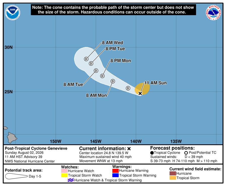
Constructed guidance: Not the official NHC forecast
Advisory Timeline
Advisory Timeline
GENEVIEVE BECOMES A POST-TROPICAL CYCLONE. THIS IS THE LAST NHC ADVISORY. As of 11:00 AM HST Sun Aug 02 the center of Genevieve was located near 24.8, -139.5 with movement WNW at 13 mph. The minimum central pressure was 1009 mb with maximum sustained winds of about 40 mph.
Official NHC advisory text
...GENEVIEVE BECOMES A POST-TROPICAL CYCLONE... ...THIS IS THE LAST NHC ADVISORY... As of 11:00 AM HST Sun Aug 02 the center of Genevieve was located near 24.8, -139.5 with movement WNW at 13 mph. The minimum central pressure was 1009 mb with maximum sustained winds of about 40 mph.
Source: NOAA / NHC
Advisory Timeline #38
Genevieve forecast to become post-tropical later today.
Official NHC advisory text
ZCZC MIATCPEP2 ALL
TTAA00 KNHC DDHHMM

BULLETIN
Tropical Storm Genevieve Advisory Number  38
NWS National Hurricane Center Miami FL       EP072026
500 AM HST Sun Aug 02 2026

...GENEVIEVE FORECAST TO BECOME POST-TROPICAL LATER TODAY...


SUMMARY OF 500 AM HST...1500 UTC...INFORMATION
----------------------------------------------
LOCATION...24.5N 138.4W
ABOUT 1800 MI...2900 KM W OF THE SOUTHERN TIP OF BAJA CALIFORNIA
MAXIMUM SUSTAINED WINDS...45 MPH...75 KM/H
PRESENT MOVEMENT...WNW OR 295 DEGREES AT 14 MPH...22 KM/H
MINIMUM CENTRAL PRESSURE...1006 MB...29.71 INCHES


WATCHES AND WARNINGS
--------------------
There are no coastal watches or warnings in effect.


DISCUSSION AND OUTLOOK
----------------------
At 500 AM HST (1500 UTC), the center of Tropical Storm Genevieve was
located near latitude 24.5 North, longitude 138.4 West. Genevieve is
moving toward the west-northwest near 14 mph (22 km/h). This general
motion is expected to continue over the next day or so, followed by
a decrease in forward speed and a turn toward the northwest by
Tuesday.

Maximum sustained winds are near 45 mph (75 km/h) with higher gusts.
Gradual weakening is forecast, and Genevieve is expected to become a
post-tropical cyclone later today.

Tropical-storm-force winds extend outward up to 80 miles (130 km)
from the center.

The estimated minimum central pressure is 1006 mb (29.71 inches).


HAZARDS AFFECTING LAND
----------------------
None.


NEXT ADVISORY
-------------
Next complete advisory at 1100 AM HST.

$$
Forecaster Adams/Hagen

NNNN
Source: NOAA / NHC
Advisory Timeline #37
Genevieve forecast to become post-tropical on sunday.
Official NHC advisory text
ZCZC MIATCPEP2 ALL
TTAA00 KNHC DDHHMM

BULLETIN
Tropical Storm Genevieve Advisory Number  37
NWS National Hurricane Center Miami FL       EP072026
1100 PM HST Sat Aug 01 2026

...GENEVIEVE FORECAST TO BECOME POST-TROPICAL ON SUNDAY...


SUMMARY OF 1100 PM HST...0900 UTC...INFORMATION
-----------------------------------------------
LOCATION...23.9N 137.3W
ABOUT 1735 MI...2790 KM W OF THE SOUTHERN TIP OF BAJA CALIFORNIA
MAXIMUM SUSTAINED WINDS...50 MPH...85 KM/H
PRESENT MOVEMENT...WNW OR 290 DEGREES AT 13 MPH...20 KM/H
MINIMUM CENTRAL PRESSURE...1003 MB...29.62 INCHES


WATCHES AND WARNINGS
--------------------
There are no coastal watches or warnings in effect.


DISCUSSION AND OUTLOOK
----------------------
At 1100 PM HST (0900 UTC), the center of Tropical Storm Genevieve
was located near latitude 23.9 North, longitude 137.3 West.
Genevieve is moving toward the west-northwest near 13 mph (20 km/h).
This general motion is expected to continue through the end of the
weekend, followed by a decrease in forward speed and a turn toward
the northwest on Monday.

Satellite-derived winds indicate that the maximum sustained winds
are near 50 mph (85 km/h) with higher gusts. Gradual weakening is
forecast, and Genevieve is expected to become a post-tropical
cyclone by late Sunday.

Tropical-storm-force winds extend outward up to 80 miles (130 km)
from the center.

The estimated minimum central pressure is 1003 mb (29.62 inches).


HAZARDS AFFECTING LAND
----------------------
None.


NEXT ADVISORY
-------------
Next complete advisory at 500 AM HST.

$$
Forecaster Blake

NNNN
Source: NOAA / NHC
Advisory Timeline #36
Genevieve continues moving west-northwestward over open waters.
Official NHC advisory text
ZCZC MIATCPEP2 ALL
TTAA00 KNHC DDHHMM

BULLETIN
Tropical Storm Genevieve Advisory Number  36
NWS National Hurricane Center Miami FL       EP072026
500 PM HST Sat Aug 01 2026

...GENEVIEVE CONTINUES MOVING WEST-NORTHWESTWARD OVER OPEN WATERS...


SUMMARY OF 500 PM HST...0300 UTC...INFORMATION
----------------------------------------------
LOCATION...23.5N 136.0W
ABOUT 1655 MI...2665 KM W OF THE SOUTHERN TIP OF BAJA CALIFORNIA
MAXIMUM SUSTAINED WINDS...45 MPH...75 KM/H
PRESENT MOVEMENT...WNW OR 290 DEGREES AT 14 MPH...22 KM/H
MINIMUM CENTRAL PRESSURE...1004 MB...29.65 INCHES


WATCHES AND WARNINGS
--------------------
There are no coastal watches or warnings in effect.


DISCUSSION AND OUTLOOK
----------------------
At 500 PM HST (0300 UTC), the center of Tropical Storm Genevieve was
located near latitude 23.5 North, longitude 136.0 West. Genevieve is
moving toward the west-northwest near 14 mph (22 km/h). This general
motion is expected to continue through the end of the weekend,
followed by a decrease in forward speed and a turn toward the
northwest on Monday.

Maximum sustained winds are near 45 mph (75 km/h) with higher gusts.
Some weakening is forecast during the next 48 hours. Gradual
weakening is forecast, and Genevieve is expected to become a
post-tropical cyclone by late Sunday.

Tropical-storm-force winds extend outward up to 140 miles (220 km)
from the center.

The estimated minimum central pressure is 1004 mb (29.65 inches).


HAZARDS AFFECTING LAND
----------------------
None.


NEXT ADVISORY
-------------
Next complete advisory at 1100 PM HST.

$$
Forecaster Mahoney/Pierce/Cangialosi

NNNN
Source: NOAA / NHC
Advisory Timeline #35
Genevieve forecast to gradually weaken.
Official NHC advisory text
ZCZC MIATCPEP2 ALL
TTAA00 KNHC DDHHMM

BULLETIN
Tropical Storm Genevieve Advisory Number  35
NWS National Hurricane Center Miami FL       EP072026
1100 AM HST Sat Aug 01 2026

...GENEVIEVE FORECAST TO GRADUALLY WEAKEN...


SUMMARY OF 1100 AM HST...2100 UTC...INFORMATION
-----------------------------------------------
LOCATION...23.3N 135.0W
ABOUT 1590 MI...2565 KM W OF THE SOUTHERN TIP OF BAJA CALIFORNIA
MAXIMUM SUSTAINED WINDS...45 MPH...75 KM/H
PRESENT MOVEMENT...WNW OR 285 DEGREES AT 14 MPH...22 KM/H
MINIMUM CENTRAL PRESSURE...1003 MB...29.62 INCHES


WATCHES AND WARNINGS
--------------------
There are no coastal watches or warnings in effect.


DISCUSSION AND OUTLOOK
----------------------
At 1100 AM HST (2100 UTC), the center of Tropical Storm Genevieve
was located near latitude 23.3 North, longitude 135.0 West.
Genevieve is moving toward the west-northwest near 14 mph (22
km/h). This general motion is expected to continue through the
end of the weekend, followed by a decrease in forward speed and a
turn toward the northwest on Monday.

Maximum sustained winds remain near 45 mph (75 km/h) with higher
gusts. Gradual weakening is forecast, and Genevieve is expected to
become a post-tropical cyclone by late Sunday.

Tropical-storm-force winds extend outward up to 140 miles (220 km),
mainly to the north of the center.

The estimated minimum central pressure is 1003 mb (29.62 inches).


HAZARDS AFFECTING LAND
----------------------
None.


NEXT ADVISORY
-------------
Next complete advisory at 500 PM HST.

$$
Forecaster Hagen

NNNN
Source: NOAA / NHC